SB: Steve Bradley, Associate Professor, Visual Arts, UMBC. Professor Bradley is a media artist who focuses on the role of sound in society with particular interests in deep listening and acoustic ecologies.
NK: Nicole King, Assistant Professor, American Studies, UMBC. Professor King works on cultural and political histories of places and the tensions of preservation and development that connect the past and the present.
MS: Michelle Stefano, Folklorist-in-Residence, American Studies, UMBC. TETI co-founder and interviewer.
From community building to chemical dumping, the industrial urban landscape holds stories of the wonders and the horrors of the history of the United States of America. “Mapping Baybrook” is a collaborative and interdisciplinary exploration of place that blends digital mapping technologies with research into the history and culture of an industrial community in Maryland referred to as Baybrook—a merging of the names of two neighborhoods Brooklyn and Curtis Bay. This community is a mix of diverse but connected neighborhoods located along the southeast coastline of Baltimore City.
SB: The collaboration with [Professor] Nicole King through Mapping Baybrook
is kind of where things have actually all come together in a real nice way.
However, going back a bit, I have always been attracted to industrial towns,
particularly seaports and harbors. In 2006, the Baltimore-Rotterdam Sister City
Committee invited me to be an exchange artist with Rotterdam and I said, of
course, yes. And not to go into too much of the complications of the project,
I basically took the bull by the horns and went to Rotterdam fairly well-funded,
but I pretty much had to invent everything when I got there. I had no infrastructure
support, so I spent two months basically walking the streets, recording all
along the harbor the ambient sounds and interviews with people, trying to find
a thread that would make sense. I discovered this little harbor town, Heijplaat,
which is off to the Southwest of the center of Rotterdam and on the Southern
side of the harbor, the less affluent side. And if you look at Baltimore City
and the harbor, you have the Inner Harbor, where there is the wealth and the
tourism, but if you go over the harbor, to the South side of the harbor, to
the South East, the economic levels really drop. There is a lot of poor, struggling
communities all the way from Cherry Hill, Baybrook, Curtis Bay, but even slightly
North, there is an historical African-American community, Westport, and so that
whole corridor…of course, industry is on the coast line. So, [the industries]
occupy the beautiful edge of the water, which is where many people want to live
and work and access to edges of water is mostly rare.
NK: My work explores the politics and aesthetics of places as they undergo social
change. I am interested in the interpretation and preservation of historic but
overlooked places in the U. S. through a narrative approach to history and culture.
My recent book Sombreros and Motorcycles in a Newer South: The Politics
of Aesthetics in South Carolina’s Tourism Industry (University Press
of Mississippi, 2012) argues that the rise of independent sites of recreational
tourism and their role during the push for desegregation in the South has been
an important social and economic force in refashioning a Newer South. My research
focuses on the South of the Border roadside attraction and the historically
black resort town of Atlantic Beach as they blend local and global aspects of
tourism development in ways that are complex, sordid, and beautiful. I see similar
connections of power, place, and aesthetics in the Baybrook community of extreme
South Baltimore. For me, beauty comes from tension, which often produces a layered
landscape that tells a complex story.
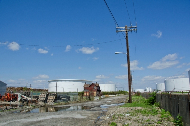
SB: So, the history of these areas is complicated and the CSX [rail-based freight transportation corporation] railroad runs through and severs these communities. In the older communities of Fairfield and Hawkins Point and Wagner’s Point, they scrubbed these neighborhoods and moved everybody out and this is the very last building I photographed:
Figure 2: Last house standing in the Fairfield area.
Nicole and I interviewed the family that used to live in this house surrounded by oil drums and you can see off in the landscape the Southeastern part of the harbor where the shipping industry, the Navy, and cruises enter and exit out of the neighborhood. But this neighborhood has been totally decimated and scrubbed…
NK: The Greater Baybrook area includes the past and present neighborhoods of Brooklyn, Curtis Bay, Fairfield, Hawkin’s Point, Masonville, and Wagner’s Point. The industrial peninsula (where Masonville, Fairfield, and Wagner’s Point were located) is also referred to simply as “the Point” or the Fairfield peninsula. I use the term “community” to signify the shared history and interests of this entire Baybrook area and use “neighborhood” to reflect the distinct sub-communities of residents closely connected by geography, character, and often race or ethnicity. My current historical research focuses on the “lost neighborhoods” of the industrial peninsula of Baybrook—Masonville, Fairfield, and Wagner’s Point. These neighborhoods no longer physically exist; yet, they offer important stories that illustrate the trajectory of urban industrial development and connect this specific story to the current social and economic development of Baltimore and other post-industrial port cities.
Masonville, a small community of primarily German and Irish immigrants working in neighboring industries, was torn down in 1952 when the B&O railroad expanded (the B&O was bought out by CSX in the 1970s). Fairfield is a fascinating community of mostly German immigrants that shifted to a community of African American migrants from the South in the early-twentieth century. Wagner’s Point was a company town built to accommodate the predominantly Polish workers of Martin Wagner’s cannery located on the industrial peninsula along the water. Following the World War II boom of the area related to the Bethlehem-Fairfield shipyards (the largest shipyard along the east coast during the war era), the area experienced a decline in importance and development. In the latter half of the 20th century, both Fairfield and Wagner’s Point suffered from the disinvestment of Baltimore City, pollution and toxic spills from nearby industry, and dumping of various sorts. The situation became so bad that the residents banded together to push Baltimore City for relocation. By the end of the twentieth century, most residents received buyouts from the City (with assistance from the federal government and neighboring industries).
When Steve and I began to work on Mapping Baybrook, these neighborhoods were almost completely wiped from the landscape. The project seeks to rebuild and retell the stories of these places through historical research and visual and audio documentation, with a focus on the experiences of residents.
Memorializing the lost neighborhoods of Baybrook pushes the public to deal with communities that have functioned as historic dumping grounds for the detritus left over from sickness (such as small pox hospitals and burial grounds), industrialization, war, and consumerism. We all need to see our own connections to Baybrook—both through our history and our current social and economic existence.
SB: So, I have done a lot of mapping; this is a large map that I made for the community to use as a way to understand their place…and this map was a kind of accident.
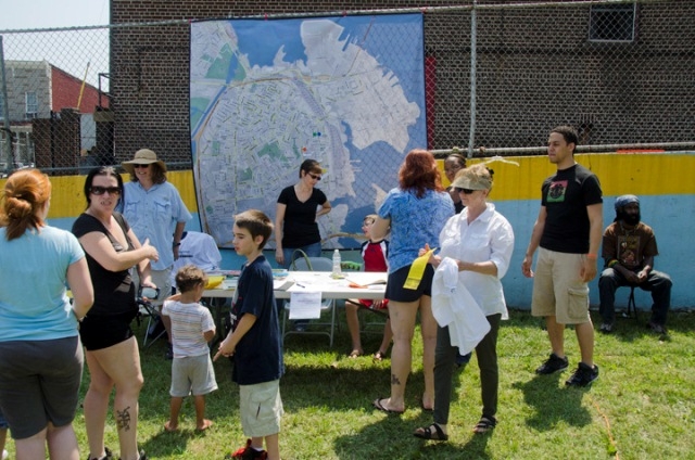
Figure 3. Large map of Baybrook.
It was a collaboration between Nicole and me. Nicole had asked me to make a map and I said, “What do you think about an eight foot map of the place?” And she said, “That sounds good.” That’s what I love about Nicole; she’s so curious about the art process. So, I made this map and we hung it up in an event that she organized and it became a centerpiece. Here’s two women arguing over the history of a location; and to me, this is the most fascinating part of the community: the community memory and how memories are debatable and not set in stone and, even when they’re in books, they’re not often accurate.
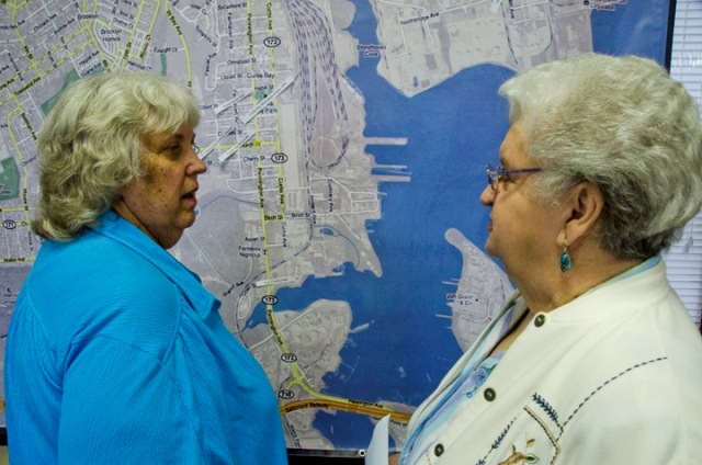
Figure 4. The map as a memory-sparker.
So, even in this conversation where two old-timers are talking about a particular location where they grew up and how they accessed it – it’s not an argument, but it’s more about them clarifying their memories and I thought that was a really great moment. What’s great about the map is that it is even inaccurate. This [map] is a borrowing from Google Maps and even the information in Google Maps is inaccurate, so they’re arguing with Google! And I think that’s probably what I’m very gifted with – in terms of collaborating with Nicole – is my ability to come up with the imaging and to use the appropriate media, as well as to see the role of archives and the importance of documenting our relationships within a place…and then just the textures of the voices, the memories, the stories by the person telling the story with their own voice, to me, is a huge piece of this. Upon hearing a voice, I am not so interested in what they’re saying – I am interested in what they’re saying, but to clarify, I’m interested in what they sound like and often their voices go back to their roots and who they are and who their parents and their parents’ parents were. We’re chameleons and we mimic what we know and often reject what we know, but become much what we’ve been raised as kids…
So, this is a community event that Nicole had organized with her American Studies class and we used this map as a kind of centerpiece. We work with local historians, who collect and harbor archives, and our goal is to take individuals like this who have a little website and maybe a little bit of information and coalesce that in a larger pool, giving them credit, of course, and homaging their effort, but putting it in a platform that makes it more accessible.
Figure 5. Local historian, Horton McCormick, and family.
Also, we’re building into this
project a flexible interface that allows the public to contribute to that conversation,
so you could upload your own family archives and stories and whatnot.
NK: What works so well about the collaboration between Steve and I is that we
often see different things. While Steve may be less interested in what people
are saying, I am very interested in these details for constructing a narrative
of the community’s development. Putting an artist and a cultural historian
together can produce a more layered understanding of place. Overall, we are
striving for the same clarity of vision, but we often see different things.
In 2008 when I started as an assistant professor in the Department of American
Studies at UMBC, I began teaching a course called “Preserving Places,
Making Spaces in Baltimore” that brings students together with a local
community in Baltimore to place its histories, narratives, and landscapes into
broader intellectual frameworks. It was through this course that I became interested
in the forgotten history of the Baybrook community. We have held two public
history/social events in the community. Steve designed the maps for the May
2011 event “Bridging Baybrook: Preserving the Past, Developing the Future,”
which was held at a community space listed on the National Register of Historic
Places—the Polish Home Hall.
It was a desire to better visualize the history and aesthetics of this community
that led to the collaboration with Steve. While we both come from different
disciplinary perspectives, we share the interest in better seeing the complex
story and the beauty of this overlooked community in the southernmost region
of Baltimore City. Steve and I agree that it is the everyday people who build
and sustained these communities that own this story. The sense of place and
aesthetics in the community are informed by the development of heavy industry
in the area (which began in the late-19th and early-20th centuries); however,
the people of the community are the ones who really fill the space with meaning
and make the landscape a place worthy of study. Steve and I work closely with
residents, including the current neighborhood associations Concerned Citizens
for a Better Brooklyn (CCBB) and the Community of Curtis Bay Association (CCBA),
the local non-profit community development corporation the Baybrook Coalition,
and the local high school, the Benjamin Franklin High School at Masonville Cove.
We have also begun the process of interviewing people who have experienced the
community’s history firsthand. The heart of our work is collaborating
with the community to tell their stories.
MS: Can we go back a bit? So, this area is one you generally call ‘Baybrook’?
SB: Yes.
MS: And that’s pretty much that peninsula you see on the map there?
SB: Yes.
MS: Just briefly, what were the people who were living there involved with –
were they working in factories?
SB: Yes. There were a number of factories that are still there. Also, there
are several chemical and oil companies, so it’s heavy industry. If you
look on the map, you can see the railroad that cuts through the community. You
can also see the coastline, where so many of the industries are located…Petrolia
Avenue, Cannery Avenue…even the street names reflect the industries. The
railroad company, CSX, is one of the big employers of this community. You can
see where the railroad cuts through Masonville Cove, which no longer exists,
but this is where a new the environmental center has been built and the surrounding
land is in the process of being caped so that residents can enjoy the waterfront.
I did a tour recently, and they are literally capping the earth because of the
toxicity and then bringing in another ten feet of earth on top of that.
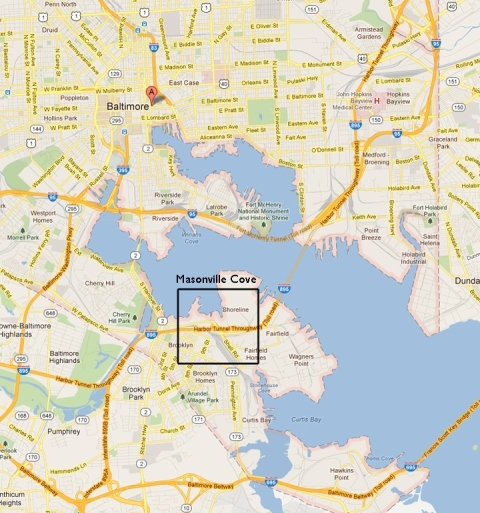
Figure 6. Map of area with Masonville Cove highlighted.
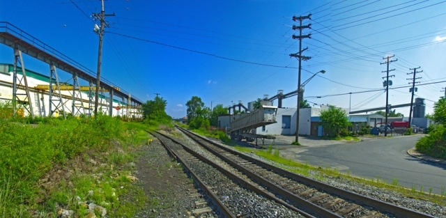
Figure 7. CSX railroad lines.
NK: The recently opened Masonville Cove Environmental Education Center, a “green” building, is a space for educating the general public and students about the natural history and resources of the community. The Center is one part of the larger Masonville Urban Nature Center, a $153 million waterfront renourishment project, involving the Maryland Port Administration and various partners, to remediate a contaminated site behind the Center and open it as a park with water access for community use. This project is part of community incentives offered to the area, once it was chosen as the site for a Dredge Materials Containment Facility. For Baltimore Harbor to properly operate and serve today’s large ships, material must be continually dredged from the Harbor and deposited nearby. The Development and Implementation of Masonville Dredged Material Containment Facility, Masonville Cove Environmental Education Center, and Associated Mitigation Plan at Masonville Cove public project received the 2010 Environmental Excellence Award from the National Association of Environmental Professionals. Part of these initiatives included funding to open Benjamin Franklin High School at Masonville Cove, the community’s first high school. This project worked with residents and has won environmental awards; however, there are always problems. For example, there is a not a feasible way for residents to walk to the Cove any longer because of the construction of an interstate.
MS: So are there still people living
on that peninsula?
SB: They have literally been moved out in the past year. Last year, we interviewed
this couple, Jimmy Drake and Debbie Mitchell. And Jimmy and Debbie used to live
in this house and before that, a guy names John Jeffries. And that’s [John
Jeffries] here.
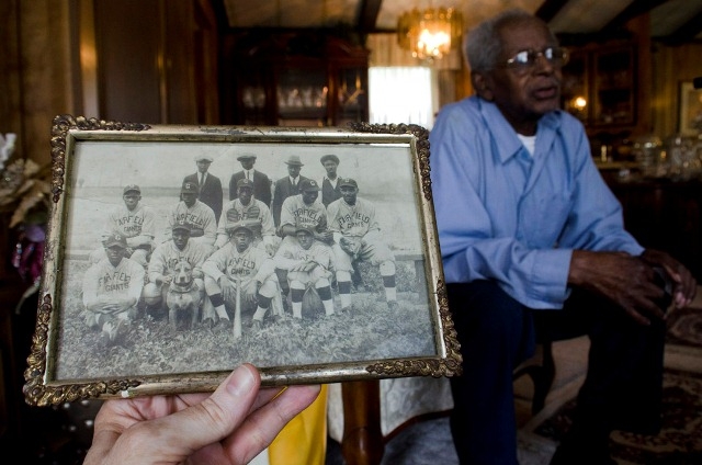
Figure 8. John Jeffries.
Jimmy’s grandfather bought
the house and then his aunt owned it and eventually took a buyout from the city.
He lives now just over the county line in Anne Arundel County.
MS: That’s where they moved everyone?
SB: Or, they moved them into the Baybrook/Curtis Bay area.

Figure 9. The Baybrook area today.
So, this is where the majority of
people lived in Fairfield and Wagners Point and Hawkins Point. But the last
people to move out [on the peninsula] are Debbie and Jimmy Drake, and that was
last March. And they tore their house down May 1st, 2011.
NK: They also relocated a large part of Fairfield’s African American community
(and probably Hawkin’s Point) into the largely black community of Cherry
Hill. Even today, Baltimore struggles with issues of racial segregation.
MS: How did you come to this project?
SB: Well, partly through the Baltimore-Rotterdam Sister City program. I want
to bring these stories from the Netherlands to the US and I was looking for
a sister community and, at first, I thought it was going to be North Avenue
[in Baltimore city center], but it just didn’t feel right. First off,
it’s not a harbor community. Then, Nicole invited me to be part of Mapping
Baybrook and I did a tour about a year ago and I said, “Oh my god! This
is the sister community.” So, I asked her what she thought about bringing
this art project into the fold and she said, “Well, this is one of the
reasons why I was interested in you, particularly your interest in place and
people’s stories.” In that same conversation, I said that I would
probably need a home-base and I heard a rumor that there was a high school that
was considered a community school, a ‘turn-around school’, and I
said, “What do you think of me housing the project within a high school?”
And it’s a community school, so I knew I would be touching base with elders
and [Nicole] said that that’s brilliant. And that’s how that happened.
We did our first tour in the community and it’s so much like Rotterdam;
it’s uncanny – the only difference is that Rotterdam is flatter.
When I look at these images, down at the bottom, they make me think that I could
be in Rotterdam. I’m fascinated by both the design – both the beauty
and ugliness – that it’s a sort of “toxic beauty” and
dangerous as well.
Figure 10. Heijplaat, Rotterdam,
Netherlands.
NK: Working in the community, I wanted a better way to see the changing landscape
and the connections of these various neighborhoods. That entailed brining someone
with Steve’s expertise in audio and visual arts (as well as design) on
board. We are also working with UMBC’s Imaging Research Center (IRC),
which is a leader in the field for developing cutting edge visualization projects—what
we like to call the online ecology.
We hope Mapping Baybrook will illustrate how the successes and failures of urban
industrial development contribute to our understanding of historic places and
the creation of social space. A central theme of the project’s online
ecology is that preserving places through virtual mapping and public humanities
programming creates social space—the room for diverse people and perspectives
to come together. The project will envision changes that have occurred in this
community throughout the arc of U.S. industrialization, with a focus on the
stories of everyday people and places. A key objective of the work is to document
and preserve the history and memories of this industrial community cut off from
downtown Baltimore by the Patapsco River, while incorporating its important
story into the urban landscape, U.S. history, and the transnational narrative
of industrialization—or what I often call the global postindustrial-industrial
condition.
Learning to see the beauty in the postindustrial/industrial landscape, while
not fetishizing it, is also an important aspect of this project for me. Every
single time I visit Baybrook, I see something new—a mural, a street scene,
kids skateboarding, a squashed rat, anything really—and it challenges
me to rethink my perspective on place in interesting ways. We want to acknowledge
that this area has been used as a dumping ground throughout history, but the
real story is how, despite difficult conditions, residents built a lovely and
lasting community. Throughout history, residents have been able to strike somewhat
of a balance between heavy industry and green space. This community is a pastiche
of various mediums. Steve’s pictures of the structures that are no longer
there have a haunting beauty, but once you talk to the people who lived in a
house for generations, there’s an entirely new layer of beauty that emerges.
The structures may no longer remain but the stories live on.
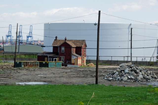
Figure 11. The “toxic
beauty” of the area (Jimmy and Debbie’s former house).
MS: It also has a very ‘inaccessible beauty’; if you’re hanging
out there, you’re probably doing something bad…
SB: Well, I always feel like I’m being watched when I’m there. It
has all been abandoned…there are a few companies still in this little
neighborhood, but I’m fascinated by the sort of discarded and the contemporary
– that these two coalesce – and the lack of care for the place.
For me, I’m looking at it as an artist and I’m attracted to these
kind of places, but at the same time there’s a recognition of a lack of
understanding of the beauty of a place and that’s it’s unfortunate
that, when you’re walking around these places, there’s toxic stuff
flowing out of the Earth. And it’s going to catch us at some point; we’re
going to be penalized for our lack of care. And I almost broke into that church
to see what it would look like on the inside and I regret that I didn’t.
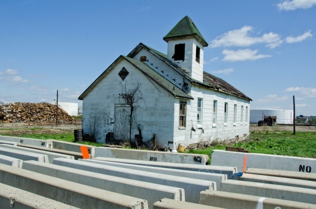
Figure 12. Abandoned church.
MS: The church is gone now?
SB: It’s gone. Literally, it’s a flat land now. I took the last
photo of it. And behind from where I took that photo is this – this is
across the street.
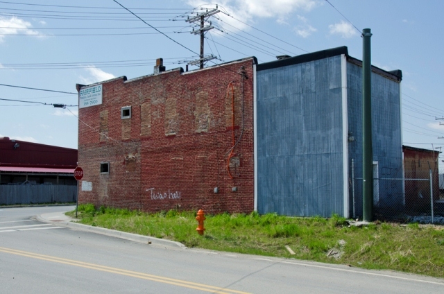
Figure 13. Across the street
from the church.
So, I’m very interested in looking at this building, which has been there
for as long as, probably, that church – maybe even longer – and
then the newer parts of the building. So, there’s this sort of archaeological
beauty – ugly, but at the same time, it is what it is. And I’m fascinated
by what is revealed through the layers of a place.
NK: For me, looking at this one place, this one house, which was located at
3306 Weedon St., can tell a fascinating story through its past inhabitants and
connections
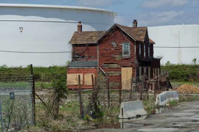
Figure 14. The Jimmy Drake
and Debbie Mitchell house.
From Jimmy Drake and Debbie Mitchell, who were moved out in March 2011, we learned
about John Jeffries, whose family told the house to Jimmy’s family in
1943. Steve and I interviewed Mr. Jeffries this past summer. His family bought
that house from a German family in the early 20th century. (I am still researching
records on that one house. Records for working-class structure in marginal places
are often difficult to research, but the detective work is certainly worth the
time and often fun.) Mr. Jeffries told us stories about the good, and the bad,
experiences of African Americans in Fairfield. Jeffries’s father knew
an important historical figure from Fairfield, John Widgeon.
Widgeon was born in 1850 to enslaved parents on the Eastern Shore of Virginia
and at nineteen came to Baltimore. He was eventually hired as a custodian at
the Maryland Academy of Sciences, the state’s oldest scientific institution
dating to 1797 (now part of the Maryland Science Center). Because of his hard
work and personal collection of species of snakes and bugs from fieldwork in
Druid Hill Park, Widgeon eventually secured a regular position doing collecting
for the Academy (in addition to his custodial duties). Widgeon traveled to the
West Indies to obtain specimens for the Academy, surveyed Indian sites in Maryland,
and collected a whale skeleton for the Academy. Widgeon often lived at the academy,
located at various addresses in the center of Baltimore City.
Near the end of his accomplished career at the Academy, Widgeon moved to Fairfield
and built the First Baptist Church of Fairfield, which opened in 1908 at the
corner of Brady Ave and Fairfield Rd. A scientist and pastor, Widgeon also wrote
essays on the condition of civil rights. His 1908 essay, “John Widgeon
To His People,” was published in the Baltimore Sun. Widgeon wrote about
civil rights in the guise of natural history—using the raccoon (playing
on the derogatory term “coon” for African Americans) and the crow
(playing on Jim Crow laws). Widgeon’s wife was also the postmaster of
Fairfield for many years. Widgeon was one of the early social and spiritual
leaders for blacks in Fairfield. Late in his career, he was awarded an honorary
Master of Science degree at a ceremony in the First Baptist Church of Fairfield.
Widgeon is on an historical market by the Enoch Pratt Library in the center
of Baltimore City; however, his connection to Fairfield is little known or discussed.
MS: Was there anything going on that was community-based, that they were initiating
to get together to talk about these changes?
SB: Yes, there’s the Brooklyn-Curtis Bay Coalition, a non-profit community
development corporation founded in 2001 and the current neighborhood associations
Concerned Citizens for a Better Brooklyn (CCBB) and the Community of Curtis
Bay Association (CCBA). I’ve been going to many of their meetings and
they talk about crime, trash, rats – issues that we all talk about in
the city and the struggle of getting the city to pay attention to those services
that need to be taken care of.
NK: This is a wonderful community. My students and I have worked with the community
association on projects such as community police walks, park clean ups, and
clothes drives. You have to be prepared to get your hands dirty and work with
a community on the projects that they value to build trust.
I am speaking about my historical research on the “lost communities”
of Baybrook (Masonville, Wagner’s Point, and Fairfield) at the CCBB, CCBB,
and the Masonville Cove Advisory Committee meetings this spring. I want to take
my research and share it with the community. I want the residents to be able
to critique and actively contribute to the story. Now, people might not always
agree (like the women in front of our map at the Polish Home Hall that Steve
previously discussed), but that’s still an enjoyable and important part
of the process.
MS: Is there any reflection on these changes?
SB: There are. We are just getting our teeth into this; Nicole and I have been
interviewing. What I hear is that quite a few of the conversations are about
the ‘good old days’ when you could leave your house unlocked and
walk down the street, and the streets were clean. And there was a consciousness
that an industry was taking better care of the communities. Similar to Heijplaat,
in the Netherlands, the industry owned the land and the houses, so if you lost
your job, you lost your home and you had to move, literally, away. So, there’s
a little bit of that, I feel, within this community. In the past three years,
the industries are beginning to pay close attention to how they treat locals
in this community. Industry is involved in some of the PR; CSX has been a frequent
visitor to the high school to attract young workers into the industry. I’ve
been also participating in the high schools to attract young people into staying
in school, finishing their degrees and, hopefully, continuing on to higher education.
Even attending a community college is a huge step for many of these young people.
Most of their parents are eighth-grade graduates, so many of them have been
siphoned off into the industry. However, the problem is that many of these jobs
are short-term jobs; I guess on the front of it, they look like they’re
permanent, but nothing’s permanent. And that’s been part of the
problem in this community: companies popping up and then disappearing and taking
the workers with them in many respects.
MS: Why is Mapping Baybrook more than just a simple, documentation effort?
SB: Well, it’s not simple! This is not an easy project, mainly because
it has taken us a long time to earn the respect and trust of the community.
I knew going into this that it wouldn’t be a six-month project, it looked
more like a six-year project, if I can say that loosely. And I’m going
into it with the idea that this is my community, not just their community. And
I know that this may sound odd for an outsider to say, but I grew up as a ‘military
brat’ and I have no real home, and I call Baltimore my home, but I don’t
really have a neighborhood that’s my home. I live in the neighborhood
in Catonsville, just near [UMBC], and my strategy for living there is that it’s
close to my work; I don’t necessarily like to commute. So, I’ve
adopted [Baybrook] and I think they are beginning to adopt me.
Also, just seeing how few opportunities the youth have to talk to professors
or artists or historians; and I think they’re kind of shocked that anybody
cares. Every Friday, I’m at the school teaching the young people about
animation and helping them visualize themselves and project positive images
of themselves using digital and social media. I think that for many of the young
people there, they look at it as an opportunity to be a little more involved
with their history-making. It isn’t easy seeing a kid that looks like
he’s been wearing the same clothing for several days and could use a shower,
and finding out that many of the kids are what they call, ‘couch surfers’.
But there’s a great deal of pride. Many of the youth know they have to
work a bit harder to get out of the situation they’re in and I think us
being there – this partnership with the high school and the community
– has really given a sense of hope that people on the ‘other side’
really care. We’re really working hard at raising the profile of this
community, so that the city pays closer attention. This is the furthest south
you can go in the city of Baltimore and it is part of the city, but the locals
feel like the city doesn’t believe that. But over the past few years,
there’s been an interesting shift, I think.
NK: I agree with Steve.
We want Mapping Baybrook to advocate an integrative approach to understanding
place as a central terrain for reinterpreting history and culture and challenge
the notion that there are “bad” neighborhoods that should be avoided
or ignored. Rather, bad policies and development practices led to the material
and social problems these neighborhoods face. These bad decisions and their
effects on people and places must be engaged and analyzed. To do so, the public
must first begin to see these places as part of our world.
MS: Do you feel that your efforts can be used in other parts of the world? I
know this is hard to say, but is there some sort of template since these problems
are common to many other post-industrial and trans-industrial places.
SB: That’s interesting; I’ve been thinking about this a lot. And
I am looking at other communities in Cincinnati, Cleveland and Detroit. In particular,
I’m thinking of Nicole’s relationship to Baybrook in studying a
boom and bust of a community and how you can prevent the bust. How do you slow
the boom in such a way that it is smart growth and thoughtful to the locals,
and that industry is not just a virus that comes and lands and sucks up the
resources after it departs, after they polluted it? You know, how do you sustain
a community? How do you supply jobs and industries so that people have reasonable
lifestyles. And we all have the right to a reasonable lifestyle; I’m not
saying that we should all be rich – I think being rich comes with a whole
other set of problems. But the middle class should really be strengthened so
that it’s sustainable. I am also interested in the beautification and
thoughtfulness in how we design our communities, or redesign communities. There
are many opportunities to take a community like [Baybrook] and think about green
spaces, linking them with bike paths and teaching young people about how to
sustain their tools. Things do change, though, and we need to build a more flexible
society; so, the more skills one has, the more flexible one is.
NK: Studying Baybrook as a specific local place is important, but the project
also offers a model for dealing with the general boom and bust cycle of industrialization.
What I am interested in is how the past can influence the future of industrial
development or the things that make take its place (other than just more waterfront
condos for rick folks). There have been many waves of development, or actually
redevelopment, in Baybrook. Some have blatantly failed and some have aspects
that can be studied to better understand the complex process and politics of
industrialization in new ways.
For example, the “lost neighborhoods” of the industrial peninsula
no longer exist, which may be a positive development for the health and welfare
of the residents. However, with the demise of the company town model the remaining
industries have no one nearby to observe or have oversight (beyond the corporations
and their employees). When the FMC chemical corporation moved its operations
from Baltimore to Asia in 2008, the last monitoring device left with the corporation.
There are fewer industries in the area, but there is also less outside oversight.
The neighborhoods of Brooklyn and Curtis Bay and their residents remain, yet
they are outside the boundaries of the industrial area—though not far
enough away not to be affected by pollution, etc.
We need more comprehensive ways to see industrial places in a larger social
and historical context. Even if most residents of Baltimore City never venture
over the Patapsco River into the Baybrook community, their discarded automobiles,
the oil that makes those automobiles run, their trash, their waste, and their
chemicals are produced and dumped in this (and similar) areas. The Brooklyn
and Curtis Bay residents of today struggle with issues of poverty, pollution,
and crime. The entire City must struggle with these issues as well. We are really
one big city. We have to learn to see the innate connection to these often-overlooked
places. The privilege to not see these places as part of your world is one that
we hope to challenge.
Yet, this is not simply a story simply about loss or poverty or pollution. It
is also about residents who struggled to build a sense of community. It is about
their tenacity and their connection to green space even as heavy industry encroached.
I want to attempt to locate the history of this area through the historical
record and the words of those who lived in and built these communities, those
who labored in nearby industries. They are an often-forgotten part of the narrative
of industrial development and post-industrial decline. This is their story,
and we hope to do it justice.
MS: On the same note, from any of your experiences, do you have any thoughts
you’d like to share on globalization, industrialization, trans-industrialization
and/or global capitalism? [Laughs.] Is there a pattern, or is there something
from all your experiences that disgusts you?
SB: Of course. I really have a lot of trouble with the history of industry coming
in and using up resources and, when it’s convenient, they leave without
taking responsibility for what they leave behind. I’m not all for regulation
either; I also feel that we, as community players, should be involved in those
decisions. I think a community like Baybrook, or Heijplaat or Detroit, needs
local-level empowerment so that these communities can take control. They need
a voice. And so a part of my agenda is to learn how to help my voice become
part of a community’s voice. What’s really important for me as an
artist in this stage of my career is that it’s not going to be an individual
who can change things, it’s going to be a community. So, partnering with
the high school and the community players within the high school…observing
this and watching this evolve has been a great teacher. Also, collaborating
with other disciplines, such as American Studies, has been one of my best teachers.
I am constantly learning new methods and approaches. I’m a really good
chameleon and I feel very privileged that I have access to computing and media
technology, and showing that back to a community who has been disconnected has
helped empower them, as well as helped them to control their media.
NK: The issues of urban neighborhoods, such as Baybrook, are not unique to Baltimore,
but speak to larger trends of urban development in post-industrial communities
throughout the U.S. and the globe. Mapping Baybrook uses urban history, historic
preservation, art, media, and activism in an attempt to understand and sustain
environmental justice—the idea that industry, pollution, and crime should
not be concentrated in areas that are socio-economically depressed and geographically
segregated. Mapping Baybrook pushes the public to deal with communities that
have functioned as dumping grounds for society’s detritus. Tactics to
address post-industrial decay, such as urban renewal and gentrification, have
often undervalued the unique built environment and the stories of working-class
people and places.
Rather than ignoring or avoiding such neighborhoods, there is a need for both
physical and digital spaces for memory, dialogue, and community building, which
Mapping Baybrook can create. While virtual mapping and public history programming
cannot reverse the ravages of history, it can help remember and interpret positive
aspects of the past in the current era and productively deal with past mistakes
and inequalities. Bringing humanities scholars and media designers/artists together
with residents to interpret the community’s history and built environment
will enrich the public’s understanding of the complexity of urban history
and the postindustrial condition.
MS: How do you envision that they will use social media? What is your hope?
SB: For instance, I had my students collaborate on a project in Baybrook and
we built a website. Some of the media they created is part of that documentation.
And part of my project is to work with elders who have been disconnected. Basically,
I am demystifying the technology and that is one way to effect change. However,
social media is an interesting animal. Even using Facebook as a way to connect…the
Brooklyn-Curtis Bay Coalition is using [Facebook] to communicate. However, not
everyone has access to the internet; the digital divide does exist here. I think
that’s where the school – being a community school with networking
and having facilities available for the locals – comes in (For more information
see: http://urbantells.net/VCIII ).
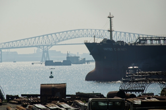
Figure 15. Baybrook Harbor.
NK: Part of the idea of Mapping Baybrook is that the residents are not simply
consumers of media. They are the producers as well. We want to work with the
community to build this online ecology to assist the general public in better
seeing the effects of post-industrialization.
Mapping Baybrook strives to develop an innovative model for using visual and
sound technology to create a multi-platform immersive experience of the community’s
history that is searchable online and accessible using mobile devices. The website
will evolve from an archive to include visualizations—an area where the
IRC is a leader in the field—and sonification—using non-speech audio
to convey meaning and auditory perception—Steve’s area of expertise.
There has been an explosion in spatial humanities work—the grounding of
historical and social research in place—using digital formats. However,
Mapping Baybrook moves beyond more text-based formats to make the map a central
aspect of the online experience. Visualizations and audio will tell the story
of Baybrook, and text will be concise, succinct, and secondary. The project
will usher in a new model that fits with the central role of images in contemporary
culture. It will also be a tool that the community can use to build a better
future.
In writing grants for the project, our ideas have been critiqued because of
a stereotypical belief that poor communities do not engage in new media practices.
This is not true. For example, Baltimore has a wonderful free public library
system (a branch of the Enoch Pratt library is in Brooklyn) with public access
and the young people at Benjamin Franklin High School can pick up new media
practices (from Steve and his students) much quicker and more skillfully that
I can. Social media should be democratic, not something for tech centers and
the wealthy. For new media projects to gain traction they must be located and
promoted on the ground and in all communities.
I would like to see community-based and place-based digital mapping projects
spread throughout Baltimore and other cities across the global. Using new media
technologies we could have high school students in Curtis Bay (Baltimore, U.S.A.)
taking to students in Heijplaat (Rotterdam, Netherlands) and realizing that
their worlds are really not that different. And even better, such an experience
could cause young people to see their own ability to shape the future of their
communities and the larger world.
For more information about the Mapping
Baybrook project, please visit: http://urbantells.net